| ||||||||||||||||||||||
| disconformities and paraconformities (diastems) | Last Updated • February 16, 2008 | |||||||||||||||||||||
We have a disconformity when the layered sequences above and below the unconformity are parallel (have the same dip), and the unconformity was actually originated by erosion. Such an unconformity can be originated, for instance, by a drop in sea level, that would expose sediments to erosion, and by a later rise in sea level, that would cause sedimentation to start again. During the time the surface was eroded, not only we have no sedimentation (no new record) at that location, but we also have removal of previous deposits: the erosion surface represents a break in sedimentation, or a time gap. A disconformity implies that:
Hence, even without erosion, simple non-deposition causes a gap in time, that is an unconformity.
How can we tell if we have a paraconformity instead of a disconformity? A paraconformity (diastem) implies that:
The following image shows an interpreted paraconformity: 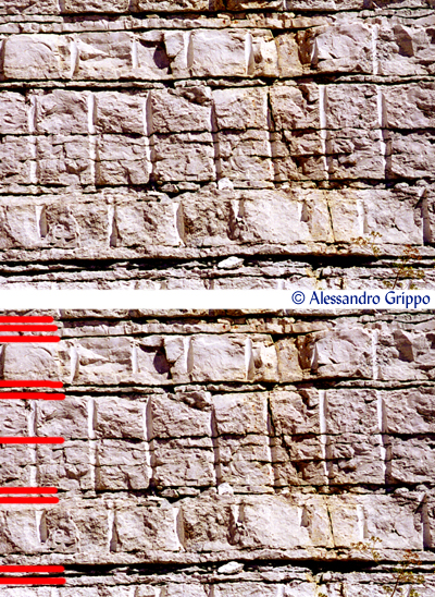 This sequence represents a structural high: an area at the bottom of the ocean that was elevated compared to the ocean floor. As a consequence, this sequence is slightly different in composition and more "condensed" in its thickness, when compared to an open ocean one. In particular, these are limestones layers (Bugarone Formation), separated by darker shales: when sedimentation patterns changed, limestones sedimentation rates dropped to zero, and only the less abundant clays remained around. There is a significant amount of time represented in these thin shales (that is our paraconformity). Fosso Bugarone, Piobbico, Pesaro e Urbino (Italy)
Both image and interpretation are by Alessandro Grippo. I marked in red only the left part of some of the shale intervals, where the diastems are more significant)
| angular unconformities
| Last Updated • February 16, 2008 |
Angular unconformities occur when the beds beneath an erosional surface are tilted and eroded. Above and below the erosional surface we always find sedimentary rocks. At Siccar Point, in Scotland, James Hutton was able to understand how the age of Earth had to be much older than that estimated at the time (about 6000 years). Hutton observed two different units with distinct layers of sedimentary rocks. These units were apparently at right angles to each other: the units did not appear to be conform to the regular superposition pattern (one younger horizontal layer on top of another older one). Hence, he termed the contact betweeen the units as an UNCONFORMITY. Since the layers are at an angle, this in particular is called an angular unconformity An angular unconformity implies that:
The following images show two interpreted classic European outcrops: 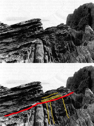 In this image we are taking a look at the outcrop James Hutton saw at Siccar Point: here, vertical Silurian greywackes and shales are found underneath Upper Old Red Sandstones of Devonian age. The contact between these two units is our angular unconformity. Siccar Point, Berwickshire, southern Scotland (United Kingdom) (The unmodified picture is from the British Geological Survey, and it has been found on The Key to Earth History, by P. Doyle, M.R. Bennett and A.N. Baxter, 2001 - Wiley. The interpretation is by Alessandro Grippo. In red is the angular unconformity, in yellow some of the beds from the two units, to give the sense of the stratification pattern). 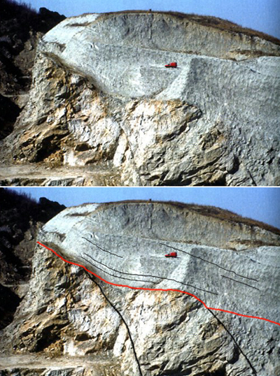 This second image shows another spectacular angular unconformity between the Messinian (Miocene) gypsums of the Gessoso-Solfifera Formation and the Pliocene muds of the Colombacci Formation in the Apennines of northern Italy. The contact between these two units is our angular unconformity. Monticino quarry, Brisighella, Ravenna (Italy) (The unmodified picture is from Gian Battista Vai, professor of Stratigraphy at the University of Bologna, and it has been found on Il Parco Museo Geologico Cava Monticino, Brisighella, by M. Sami [editor], 2007 - Carta Bianca, Faenza. The interpretation is by Alessandro Grippo. In red is the angular unconformity, in black some of the beds from the two units, to give the sense of the stratification pattern; notice the thick layers of gypsum in the lower unit, opposed to the relatively thin layers of shale in the upper unit; the red van on the quarry surface gives an idea of the relative scale of the rocks and the unconformity). | non-conformities
| Last Updated • April 1, 2010 |
Non-conformities occur when layered sediments overlie an exposed and eroded crystalline basement. Below the erosional surface we always find either an igneous or a metamorphic rock from the crystalline basement. A non-conformity implies that:
The following image shows an interpreted non-conformity from the Mojave Desert of California: 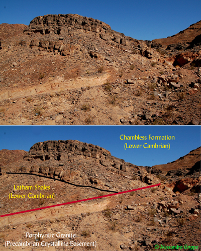 The pegmatitic granite is an intrusion dated at about 1.4 billion years ago and is part of the crystalline basement. Above the non-conformity (represented in red) is a Lower Cambrian sequence. One would expect an overall geometry of layers somehow parallel to the unconformity, but at the local scale it is not uncommon to observe contact at an angle, like the one in the picture. The Lower Cambrian sequence misses at this location the Zabriskie Formation (which is found immediately to the right of the area) and starts with the trilobite-rich Latham Shales, followed by the oncolite-rich Chambless Formation. Marble Mountains, Cadiz (San Bernardino county), California (Both image and interpretation are by Alessandro Grippo. In red is the non-conformity, in black the contact between the different formations). | The Grand canyon: an area where all three kinds of unconformities are exposed
| Last Updated • April 1, 2010 |
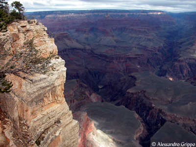
The Grand Canyon of the Colorado River is located in northern Arizona, in the southwestern United States. The whole area is part of the so-called Colorado Plateau, a region subject to rapid uplifting because of plate tectonic activity. This rapid uplifting has caused the Colorado River and its tributaries, including major ones such as the Green River, the Paria River, the San Juan River, and the Little Colorado River, to carve deeply incised valleys (canyons) into the Plateau. One of the areas of greatest rock vertical exposure can be found by Grand Canyon Village, in the heart of Grand Canyon National Park, on the southern rim of the canyon. A vertical profile can be drawn and rocks can be interpreted.  This image, taken from Doyle et al. (2001) shows:
That is, the amount of time missing at every unconformity, either because of erosion or because of non-deposition, is enormous. Our record is, once again, vastly incomplete.
Notice also that the top of the Grand Canyon (the rocks that you would walk on if you were for instance at the park Visitor Center) is Middle Permian in age. That means that, at this location, we are missing the whole geologic record from the Middle Permian to the Present (which includes all of the Mesozoic and all of the Cenozoic, more than 250 million years). © Alessandro Grippo, 1994-2010 | |||||||||||||