| ||||||||
| Introduction | Last Updated • May 7, 2019 | |||||||
This chapter deals with the Permian and the Triassic Periods. The Permian/Triassic boundary is also the boundary between the Paleozoic and the Mesozoic Eras (see figure below). As you remember the major boundaries between Eras are marked by dramatic extinctions: at the Permian/Triassic boundary, approximately 95% of all life forms disappeared from Earth. After the Triassic extinction, life rose again but the Triassic organisms were very different from before. There are no major Lagerstätten of Permian or Triassic age in North America, except for Buck Mountain in Nevada and the Chinle Group of Arizona and New Mexico. The Chinle Group is famous for its "Petrified Forest" but it is also very important because it includes both amphibious reptiles and terrestrial reptiles (which ultimately originated mammals), and some of the early dinosaurs. The Chinle Group, its rocks, and its fossils are the object of this chapter.
 The Permian and the Triassic in the Geological Time Scale
| The Chinle Group
| Last Updated • May 7, 2019 | After the end-Permian extinction, trilobites, eurypterids, and graptolites are extinct; brachiopods released their dominant position as animals on the sea floor to bivalved mollusks; coral reefs are being built by new species; reptiles have diversified and grown significantly in size, and among plants, gymnosperms, conifers in particular, are now the dominant flora on land. Earth also looked different geographically: most land masses were clustered together in a supercontinent called Pangea, and ocean waters surrounded Pangea in what is called the Panthalassa Ocean. Pangea stretched from pole to pole, but climate was much warmer then than today, and there were no ice caps. The poles had a monsoonal weather patterns (a dry season and a wet season, like the Indian subcontinent today) but most of the land was hot and dry. Oceans were warmer than today, with temperatures similar to the tropical seas of today. On this page is a series of maps of Earth. Look under "Mesozoic Era" for maps at the end of the Triassic: they can be found in the last row. Once you find your map, click on it and it will be enlarged. What is now North America is at the top left of the continental mass depicted in the images. Below "North America" you can easily identify the united masses of future South America and Africa. Here is instead a series of maps of North America. Look under "Mesozoic Maps" and on the last row there is the Triassic. Again, once you find your map, click on it and it will be enlarged. You can easily recognize most of the familiar Canadian provinces and American states on this map. Right after the beginning of the Triassic, the surviving mammal-like reptiles flourished again, and originated the first mammals by the end of the Triassic. Still, it was the amphibious reptiles that dominated Earth at first, to eventually leave that role to dinosaurs, which also appeared in the Late Triassic. The Petrified Forest National Park extends through spectacular badlands in northeastern Arizona, and has the world largest concentration of petrified wood from the Triassic Period. 
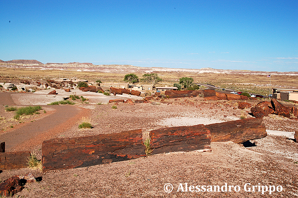
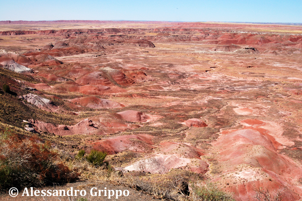
Two different aspects of the Petrified Forest area landscape (Painted Desert) The first fossils were found in 1849 in the Canyon De Chelly area, further north, and more materials were found in the 1850s south of the present-day National Park. The construction of the transcontinental railroad in the area and the arrival of tourists saw the removal of several of these fossils, which led President Theodore Roosevelt to declare this are a National Monument in 1906 Later on more land was added to the Monument but it was only in 1962 that the Petrified Forest became a national Park. This whole area, the park and the region around it, is known as the Painted Desert because of the beautiful colors found in the landscape (see the images above and the one below).  A National Park informative panel from the Petrified Forest The Petrified Forest trees were first described as Araucaria, a kind of coniferous tree which is common today in the Chilean Andes. It is important to keep in mind that, despite the fact that the park is named "Petrified Forest", it is so named because it used to be a forest. Today it is in a desert (the Painted desert). A live Araucaria forest would of course look different:

A Chilean Araucaria forest today, from Jardineriaon.com. The Chinle Formation was named for layers containing fossilized trees in the Chinle Valley of Arizona, but previously discovered time-equivalent layers from Ghost Ranch Quarry in New Mexico had yielded dinosaur bones instead. A much more varied and complete collection of macrovertebrates and microvertebrates was later discovered in the Placerias Quarry in Apache County, Arizona. At this location, among other taxa, dinosaurs, mammal-like herbivore reptiles, and crocodile-lied carnivorous reptiles were found. Read the initial part where the nomenclature and lithology are discussed, but there will be no questions about it. Know the part that begins with "Taphonomically, the Chinle Group can be regarded as...". This section tells you that:

These Araucarioxylon arizonicum petrified logs, found by the Petrified Forest National Park visitor center, show alignment in one direction only,
There would be no detailed questions from this section. Read it in its entirety but know what kind organisms have been found:
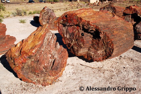
 A petrified trunk of Araucarioxylon arizonicum, showing growth rings on transverse section  A petrified trunk of Araucarioxylon arizonicum, showing growth rings on longitudinal section This section deals with the ancient sedimentary environments where animals and plants fossilized in the Chinle Group used to live. The whole Chinle group represents a relatively flat floodplain, incised by both meandering and braided streams, with a few lacustrine environments. The streams carried gravel, sand, and mud from two nearby mountain chains, and were affected by strong monsoons, causing well-defined seasons, accompanied by periods of drought.
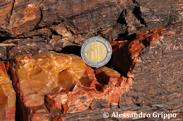
The lower unit of the Chinle is different in Arizona, where aquatic vertebrates are common, and in New Mexico, where the fauna is totally dominated by terrestrial vertebrates. Read this whole paragraph. The only thing you need to know from this section is that the Dockum Group, from Texas and eastern New Mexico, is the lateral equivalent of the Chinle Group of Arizona and western New Mexico. As a consequence, even if correlation over such a vast area is difficult, it is not surprising that the biota are very similar. This is particularly true for the floras of the Dockum, which is more closely related to the flora of the Chinle than to any other.  A detail of the "chertified" structure of the trunk in an Araucarioxylon arizonicum petrified log, from the Petrified Forest National Park, Arizona
© Alessandro Grippo, since 1994 | |||||
