| Lithostratigraphic units | Last Updated • May 16, 2015 | ||||||||||||||
Lithostratigraphy is the branch of stratigraphy that is concerned with the subdivision of a rock succession into units on the basis of gross lithology or rock type. Such a stratigraphic unit is a rock unit, and it is indipendent from time. In fact, rock units are not unique to a specific time, and can often transgress time.
The fundamental unit of lithostratigraphy is the Formation. A Formation is characterized by two important properties: Formations can be part of a group or a supergroup, and can be subdivided into members or beds. Such a classification is not obligatory: we can have Formations with no subdivisions, or Formations which are not part of any group or supergroup. If a Formation contains just one kind of rock, or one lithology, it will usually take a name that includes a geographic feature from the area where it was described and the kind of rock that makes up the formation. For instance, we speak of the Santa Monica Shale, or the Muav Limestone, or the Bright Angel Shale. If instead the formation includes more than one lithology, the geographic reference is kept but the term "Formation" is added. For instance, we speak of the Monterey Formation, or the Green River Formation. One important thing to keep in mind is that the terms "distinctive lithic characteristics" do not necessarily imply a different lithology: Formations can in fact include several different rock types, and the same lithology can change into another over distance. It is the geologist who describes the Formation in the field who decides its boundaries, or contacts with other Formations.
 The image above shows three units, from bottom to top: a quartzite (slightly metamorphosed sandstone), a shale, a limestone. Each one is distinct form the other based on their lithological characteristics. As a consequence, each unit is a Formation. Notice that the limestone includes within its boundaries a few levels of shale. The trail at the base of the outcrop works as scale.
 The rock sequence can be sketched as in the figure above. The Wood Canyon Formation does not appear in the picture, but it is recognized right underneath the Zabriskie Quartzite. The Wood Canyon is characterized by both conglomerate and sandstone, so it had to be indicated as "Formation" rather than with a rock name. Notice that all these Formations are Cambrian in age. The age is established thanks to characetristic fossils (trilobites) that are present in these Formations (but mostly in the Latham Shale). | biostratigraphic units | Last Updated • May 16, 2015 |
The use of fossils for stratigraphic correlation is called biostratigraphy. Biostratigraphic units are based on the stratigraphic range of fossil taxa. The stratigraphic range of a taxon is the total vertical interval through which that taxon occurs in the rock record, from its lowermost to its uppermost occurrence.
The most fundamental biostratigraphic unit is the zone or, more formally, the biozone.
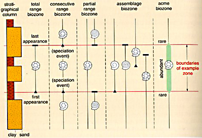
A zone is a physical body of rock (from Angela L. Coe (ed.), The Sedimentary Record of Sea-Level Change, Cambridge University Press, 2003)
to the far left is a stratigraphical column, that is a lithological description of our rocks
the total range biozone refers to one single taxon (in this case a species),
the consecutive range biozone is defined by the first appearance of a species
the partial range biozone is just a fraction of a total range,
the assemblage biozone is a zone defined by a group, or assemblage, of fossil species
the acme biozone, also called abundance biozone, is defined A big problem with biostratigraphic zones is that none of them ever represents exactly the same time interval at each location where it occurs: these zones are based on organisms, and organisms might migrate, populate an area at different times, leave an area and occupy another one, and so on. In addition to that, as you will remember from the pages on paleontology, the fossil record is vastly incomplete. For instance, what if, in a certain area or section, we were to miss exactly the first or the last occurrence of a species, or both?
In spite of these limitations, some fossils are actually extremely reliable in terms of correlation.
| chemical (isotope) stratigraphy | Last Updated • May 16, 2015 | Chemical stratigraphy, or chemostratigraphy, refers to the study of the fractionation of stable isotopes in nature. Fractionation is simply the separation of isotopes according to their different atomic weights (remember that we are dealing with stable isotopes and NOT with unstable (or radioactive) isotopes). Fractionation can occur, for instance, as a consequence of oceanographic and climatic changes. The most important fractionation processes we are going to discuss refer to the isotopes of Chapter 10 will be devoted to the chemical cycles of O and C in the natural environment, cycles that were already partially covered in class in the section about mineralogy; as such the oxygen and carbon isotopes will be discussed then.
Another important element in chemical stratigraphy is strontium (Sr).
There are two common stable isotopes of Sr in the oceans. While 86Sr exists naturally, the stable 87Sr isotope derives from radioactive decay of the unstable 87Rb (rubidium). Since 87Rb decays in time to 87Sr, the amount of this last isotopes has been increasing in the world's ocean waters since the Jurassic.
If the amount of 87Sr changed with time, as a consequence so did the ratio 87Sr/86Sr. 
What kind of samples are we looking for when we study 87Sr/86Sr isotopic ratios?
By knowing the mathematical relation between the ratio value and time, we can establish when the organism lived.
Please note that this kind of isotope stratigraphy, or chemical stratigraphy method | |||||||||
