HISTORY OF A LAKE (or, rock units vs. time-rock units)
question 1, parts a and b, left column, page 75
- 1a - Rock unit Y (a limy shale, that is a shale containing small amounts of limestone) is labeled at section 1. It is also recognizable in section 3. How? Rock units are identified based on their lithological characteristics. In order then to find the same rock unit, the minimum requirement is that lithologies match. Looking at the different sections in Fig. 8.2, page 73, you could easily see that the only one for which lithology is the same is section 3.
- 1b - Which of the methods described in the lab manual did you use to make the correlation? In order to answer this question you need to review what correlation means. For this exercise we are working with rock units, so by definition we are NOT dealing with time. Correlation then proceeds by "similarity of rock type" as we said in lecture, or as more generically described on your lab manual, by characteristic feature.
question 2, parts a and b, left column, page 75
- 2a - This question is similar to the previous one. Using the same reasoning, we can see that unit Q, labeled in section 1, is also found in sections 2, 3, 4, and 6.
- 2b - Correlation occurs as before because of characteristic feature, but if you notice the position of unit Q in section 1 you will see that it lies between two peat layers (sections 1 and 2), or just below the uppermost one (sections 3, 4, 6). Correlation then also occurs because of distinctive position in a sequence.
question 3, parts a and b, left column, page 75
- 3a - Again, in this case unit S is a rock unit: a sand with ripples marks as a characteristic sedimentary structure. At first, unit S is similar to unit Q but notice that it lies above a peat and it is similar to the upper sand of section 4. In section 4, the upper sand lies on top of peat, which lies on top of our unit Q. So, units S and Q are definitely different (even if they had not been labeled differently), and S will correlate with a layer on top of the uppermost peat. But the only layer with that position and which is also a sand is found in section 4.
- 3b - Based on what stated above, correlation occurs by both characteristic feature and distinctive position in a sequence.
question 4, left column, page 75
Given the reasoning and the answer to question 3b, the peat is most probably correlative to unit P.
question 1, right column, top of page 75
This time you are correlating different rocks that were deposited during the same time interval. So what you are looking for now are the fossils, and not the rocks. When you work with fossils, you will see that rock unit D contains the same fossils of rock unit Y in section 1, so both units (D and Y)were deposited at the same time.
question 2, right column, top of page 75
The same reasoning used for the previous question will lead you to the conclusion that rock unit S contains the same fossils of rock unit Y in section 1, so units S and Y were also deposited at the same time.
question 3, right column, top of page 75
Because it reflects uniform conditions at the bottom of a basin and because of its position in the sequence.
question 4, right column, top of page 75
Just connect the top and the bottom of the corresponding time-equivalent rock units in Figure 8.2 page 73.
question 1, right column, bottom of page 75
Because section 2 is more distal (away from the sediment source) and section 6 is more proximal (close to the sediment source).
Unit D is constituted by gravel and coarse, cross-bedded sandstones. It is a delta, as you can tell from the kind of sediment and from the sedimentary structures in it, but also from the paleogeography depicted in figures 8.1, page 73, and 8.3, page 75.
When you have cross-bedding on such a great scale, sedimentation does not occur vertically but by adding materials on the side. Time-surfaces are then diagonal and not horizontal. As a consequence, the older sediments would not be at the bottom of the sequence, but on its side. This is exactly the case for this figure: Jugus firewateri is the only "fossil" present on the left of the figure, because that is where the older sediments are. Over time, sedimentation shifts towards the right. But over time, the bottles "evolve" from Jugus firewateri to Bottleus breweri. That is why at 6 you only find the first, and at 2 you find both.
question 2, page 76
Simply because the area of unit S is more proximal (close) to the edge of the basin (our lake), so it receives coarser sediment than the more distal area of unit Y, where only clays (and hence shales) can settle.
question 3, page 76
The two fossils indicate very distinct environments. respectively muddy bottoms vs. sandy shores. They are hence environmental indicators.
question 4, page 76
Because of a different rate of sedimentation (higher for sand, lower for clay); because of the way layers are deposited (diagonally for sand, horizontally for clay); because of the limited area where sand settles, as opposed to the whole lake area for the clay.
question 5, page 76
This question requires an interpretation of the environment based on rocks and fossils. The rock in question is a cross-bedded sandstone, and it can only form in a high-energy environment, where water or wind can carry sand and create cross-beds. This is possible in deltas, rivers (point bars) and deserts (sand dunes). A delta should be excluded because there would be also some clay at some levels in smaller units (beds). The other two possibilities are both continental environments, which fit well with the peats and the lake of units D, Y and S, also continental. The presence of bison skull fragments indicate an environment where these animals could somehow survive. Most likely a wet plain, with the presence of a river, potentially excluding a lake at this location.
THE STANDARD GEOLOGIC COLUMN
Figure 8.5, parts a, b, page 78
- the correct sequence, bottom to top, is: basement, L, O, R, V, W
- the correct sequence, bottom to top, is: basement, S, D, M, P, T, J, K, C
MAGNETOSTRATIGRAPHY
question 1, page 84
Just follow the procedure we have discussed in class for graphic correlation
question 2, page 84
From page 83 of your lab manual:
"While the sediment is still wet and uncompacted, magnetic particles may continue to move into alignment, but once the sediment becomes compacted or cemented, the remanent magnetism is locked in".
So, if the sediment is saturated with water, the acquisition of DRM (detrital remanent magnetism) would be enhanced.
question 3, page 84
The system would be re-opened, the original TRM lost, and a new one acquired. Information about the TRM would not match information about the numerical age of the rock.
question 4, page 84
You would need a magnetic "signature" (a pattern of reversals) but even better, dating of the rocks.
question 5, page 84
Isochronous means "at the same time". If something that happens at the same time is recorded in rocks from all over the world, it means that you have at hand a very powerful tool for correlation: on a global scale, in avery short amount of time, that is exactly what we need.
question 6, page 84
Because of the organization of Earth in concentric spheres, because the outer core is liquid, because a "straight" magnet would probably not cause an yearly polar wander.
question 7, page 84
The geographic poles are simply the intersection between Earth's surface and the Earth's rotational axis. Magnetic and geographic poles are relatively close because of Earth's rotation
FORMATIONS OF THE COLORADO PLATEAU
1 - The Grand Canyon of the Colorado River , Arizona
question 1, page 84
Simply draw the contact
question 2, page 84
Simply draw the contact
question 3, page 84
Simply draw the contact
question 4, page 84
When you compare Figure 8.9 with the columnar section of Figure 8.8 you can see that the Grand Canyon Series of Precambrian Age is not visible at several locations underneath the Lower Cambrian. That happens, as you can see (again) from the figure because of the offset caused by a normal fault
question 5, parts I, II, and III, page 84
- the Vishnu Schist is a metamorphic rock, the Grand Canyon Series is a sedimentary rock unit. As a consequence, this unconformity is a Non-conformity
- both the Grand Canyon Series and the Cambrian are represented by sedimentary rocks, but the Grand Canyon Series is tilted (not horizontal). As a consequence, this unconformity is an Angular Unconformity
- "If each of these indicates an episode of mountain building, which is likely to have been the longest duration?"
The first one (non-conformity).
question 6, parts I and II, pages 84 and 86
- Since the Devonian is on top of the Cambrian, we are missing the Ordovician and the Silurian. Both Devonian and Cambrian are represented by horizontal sedimentary rocks. As a consequence, this unconformity is a disconformity.
- According to your textbook, the top Cambrian is dated at 488 million years (my) ago, and the base of the Devonian at 416 my ago. Assuming that you are only missing the Ordovician and the Silurian in their entirety, and not any portion of the Cambrian or the Devonian, the minimum length of geologic time at this unconformity is (488-416) my, that is 72 million years
question 7, parts I, II, and III, page 86
This question has been skipped, because it is identical (an editor's typo) to question 7, page 87
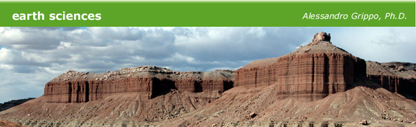
2 - Capitol Reef National Monument, Utah
question 3, page 87
Because of the presence of red shales and sandstones, some limestones, crossbedding, and ripples, the Moenkopi Formation represents a terrestrial to transitional facies
question 4, page 87
The Shinarump Conglomerate is a member of the Chinle Formation
question 5, page 87
Below the Moenkopi Formation you would expect the Kaibab Limestone
question 6, page 87
More resistant cliffs are found in sandstones and in limestones
Less resistant cliffs are found in shales
question 7, page 87
- They are resistant cliffs, they are light in color, and they are above the Moenkopi Formation. The only possible answer is that these erosional forms developed in the Navajo Sandstones, or Navajo Formation as it is listed in the geological section of the Grand Canyon area (page 85)
- Yes, if the climate here were humid,instead dog semi-arid, this formation would show a significantly different weathering pattern
- Because a higher weathering activity would increase erosion and mass wasting, probably also favoring a total or partial colonization of the area by vegetation
Back to Top | Back to Labs | Back to Home Page
© Alessandro Grippo, since 1994
Los Angeles, California