AG logo

 Images from the Spring 2008 field trip

to the Carrizo Plain, the Cuyama Valley and the Wheeler Gorge


field trip leader: Dr. Alessandro Grippo, Ph.D.


travertine waterfall

A natural spring along the Wheeler Gorge
causes deposition of travertine, a form of limestone (CaCO3).
Edson is pointing up to where the water comes to surface.
Notice the puddle by the road, and the absence of vegetation where travertine is forming.

Mario, Edson, and the rope

The Cuyama river does not seem very dangerous, but
Mario and Edson wanted to test their extreme adventure skills by using the rope across the stream.
Once the rope is pulled, people would use it.

Michael crossing the Cuyama

Across the Cuyama river Michael is trying not to get wet.

up a steep slot canyon

Using the rope actually proved more useful when we climbed the walls
of a narrow slot canyon nearby the Cuyama river valley.

trying again

Well, nobody said the first attempt was going to be successful.

what is down there?

Is that a raccoon eating my sandwich down there?

the Cuyama river

The broad alluvial plain of the Cuyama river
shows gentle meanders and different alluvial bars.

Selby campground

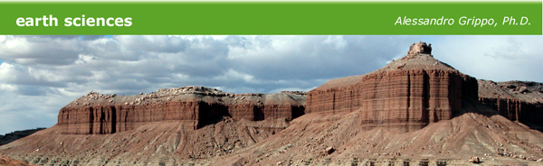
The following morning we woke up to a brisk air and rolling clouds
at the Selby campground in the Carrizo Plain, prelude to an intense day in the field.

Soda Lake, with water

This is a picture of Soda Lake in winter, when it is actually a lake.
This picture was taken during my reconnassaince in the winter, when precipitation fills the basin.
When we visited Soda Lake, water had evaporated and only salt was left (see picture below).

Soda Lake, dry

Water does not flow out of Soda Lake, so during the warmer season it is left to evaporate in the atmosphere.
When water evaporates, the salts dissolved in it are left behind to form a salt pan.

Notice how, as a consequence of the very low speed with which the water moves through the soil,
the landscape around the lake is still green.

on the salt pan

At Santa Monica College we want not only to see from a distance but also BE there:
the students are discussing the salt pan of Soda Lake while being on top of it.

crossing the San Andreas Fault

Crossing the San Andreas Fault caused the students to be spread over two different tectonic plates:
the picture was taken from the North American Plate, looking across the San Andreas Fault,
here coinciding with the small stream-incised valley of Wallace Creek, to the Pacific Plate

on the San Andreas Fault

Putting a foot on the San Andreas Fault at Wallace Creek:
what if an earthquake occurs now?

honeycomb structures

Wind erosion in sandstones caused the development of tafoni, or honeycomb structures.
Many of these cavities are currently used by birds as a pre-made, protected nest.

differential erosion

Sandstones are made of grains of sand, usually kept together by a cement.
A cement is a chemical precipitate that "glues" the individual grains one to the other.

Sometimes weathering patterns can act differently on different grains
originating what we call differential erosion:
in this case, more easily eroded materials have caused the development of a small arc along the pathway.

Wallace Creek

One last look across a plate boundary at Wallace Creek:
this time we are on the Pacific Plate, while the mountains in the background belong to the North American plate

The North American plate extends from here all the way to the middle of the Atlantic Ocean, thousands of miles away.


All pictures: © Alessandro Grippo, Carrizo Plain and Wheeler Gorge Field Trip, 2008
Go back to the Main Page  |  Go to the Owens Valley trip  |  Go the Mojave Desert and Mitchell Caverns trip

© Alessandro Grippo, 1994-2008
Los Angeles, California

last updated: June 13, 2008