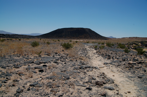
 A mile-long hike took us to the Amboy Crater.
This volcano stands out of a desert landscape formed by basaltic lava flows and Quaternary sediment.
While the landscape seems to be very barren, we apparently hiked on "lizard day":
big, multi-colored reptiles accompanied us to the base of the crater.
|
 Once we made it inside Amboy Crater we found a well-traveled path.
Probably there are not many visitors along the path, but weathering in the desert is very slow
and as a consequence every minimal alteration is preserved for very long times.
This picture was taken from the crater rim, and shows two small-sized playa lakes, located at different levels.
|
 Mario, Michael, Pam and Edson pose for a group photo on the rim of the Amboy Crater.
In the background, vast lava fields can be seen covering the ground.
|
 The path along the rim was very narrow, and both sides very steep.
A volcano like Amboy Crater is known as a cinder cone, and is composed by pyroclasts.
Pyroclasts would form during explosive volcanic activity, when magmas are extremely viscous.
|
 Later in the afternoon, we explored a small section of Bristol Lake, another playa lake of the Mojave desert.
Bristol Lake is actually mined for salt extraction.
In this image, we were walking on the salt-hardened surface of a small evaporation channel.
Note the white salt polygons, separated by salt ridges, and the mud covering the edge of the salt pan.
|
 At the end of the day we proceeded to explore some very old rocks:
in the Cadiz Mountains of the Mojave desert, Early Cambrian rocks (as old as 545 million years)
represent the ancient edge of the North American continent.
Below the Cambrian rocks, the ancient crystalline basement, the remnants of a much older continent
(about one billion year old in this area) are found.
This image shows some oncolites (coin is for scale).
Oncolites are fossil algae that lived in a Paleozoic shallow water ocean,
between the edge of the continental shelf and its adjacent slope.
Among these oncolites, which are immersed in a carbonate (limestone) mud,
it is not uncommon to find also remnants of trilobites, a characteristic fossil of the Cambrian.
|
 We camped in the open desert, at the foot of the majestic Kelso Sand Dunes
surrounded by creosote bushes, a few desert grasshoppers and butterflies and yes, we were also visited by a snake that loved the heat of our pitfire.
Edson claimed he saw a desert tortoise, but we have no pictures of it. We need to go back next year!
|
 This is how the Kelso Sand Dunes looked like from our campsite at 7.00 AM.
What a fantastic natural landscape!
|
 We were camping inside the Mojave Natural Preserve, a park managed by NPS.
NPS restored an abandoned train station (the Kelso Depot) along the Santa Fe railroad tracks
connecting Los Angeles to Las Vegas and Salt Lake City,
making it a very nice park visitor center, and a much welcomed oasis in this part of the desert.
|
 Two eyes was the ancient name of this area in the Providence Mountains:
two opening in the easily dissolved limestone give access to the Mitchell Caverns,
a medium-sized cave with very characteristic features managed by the State of California
|
 To explore Mitchell Caverns we had to take a guided tour with the park ranger.
The way into the cavern is a narrow opening into the limestone, but there is more space inside.
|
 The Mitchell Caverns have paved walkways and lighting to make the visit easy.
|
 Caves and caverns can form in rocks that can be dissolved by underground water.
Most of the times the dissolved rock is a limestone, like in the Mitchell Caverns,
but sometimes gypsum caves are found (such as the Lechuguilla Cave in New Mexico)
When limestone is dissolved, it moves with the water and then it can deposit again,
when water drips from the ceiling or the side of a cave (dripstones and flagstones.
Among these, the most known are the stalactites (hanging from the ceiling)
and the stalagmites building up from the cave floor).
When a stalactite and a stalagmite touch each other, they create a column, which is what we see in this image.
|
 The beauty of stalactites hanging from the cave ceiling made everybody stare up in awe.
(Well, not the Park Ranger, who probably leads the tour a few times a day).
|
 Strange wavy surface, similar to shallow water ripples, are found along the walls of the cave.
|
 A cluster of stalactites hangs over our group as we move on along the trail.
|
 Broken stalactites present a concentric growth pattern inside, thus pointing the way they formed
|
 A detail of the concentric growth bands is given by this polished slab of a broken stalactite
exposed outside the visitor center at the Mitchell Caverns
|
 The road back to the campground was very scenic and picturesque
and took us through mountains of limestones and boulders of granite.
|
 Later that afternoon, we started to climb the Kelso Sand Dunes,
discovering a small dune all covered with dark, iron-rich sand.
Pam seemed to enjoy the find.
|
 Actually Pam enjoyed the black sand so much that she wanted to roll down the side of the dune.
Well, at least she chose the gentler slope!
|
 On the following day, on the way home, we stopped at Rainbow Basin, by Barstow.
This area is famous for its beautifully developed (and very well exposed) syncline.
A syncline is a fold that is arched (or concave) upward: its flanks (limbs) point (dip) towards its center (core).
The syncline, with its folded layer, is covered by horizontal layer. This contact is explained (and shown better) in the next image)
|
 Sedimentary layers usually are part of a sequence of layers.
When different sequence cause layers to be at an angle with each other, an angular unconformity develops.
Unconformities indicate a gap in time that might occur when rocks between sequences
were not deposited or, like in this case, were deposited but then have later been eroded.
|
 This picture shows a single individual layer, part of the syncline structure,
bent and exposed in an exceptional way. Note the people at the top of the layer for scale.
|
 In the end, Michael and Pam wanted to see if they could catch a ride on the train
but they soon realized it would have been better to travel back to Santa Monica with the rest of us.
|