
| introduction: time units and time-rock units | Last Updated • March 31, 2015 | |||||||||||||||||||||||||||||||||||
As we said, the rapid progression of new ideas during the XIX century allowed those first earth scientists to begin subdividing bodies of rocks into geologic systems, each of which corresponding to a same-name geologic period. These subdivisions were based on the fossil content of these rocks, in particular on their range. It is important that we keep in mind the difference between a system, which is a physical, tangible body of rock, and a period, which is an abstract time interval. Before we proceed further, we must really understand this difference: pure time units are the object of study of Geochronology (with its branch of Geochronometry), while physical bodies of rock that represent time are the object of study of Chronostratigraphy. Let's take a look at both. | Geochronology and geochronometry: pure time | Last Updated • March 31, 2015 |
To give a more concrete example, we can refer to western history. We can say, for instance, that the Middle Ages, broadly defined, are a geochronologic unit: in fact they refer to a very specific interval, sandwiched between Roman Times and the Renaissance. We do not need to assign a numerical value to the Middle Ages: this name will always represent a time period that happened between Roman Times and the Renaissance. Historians may disagree on exact dates, moving up or down the lower and upper boundary of the Middle Ages, but they all agree on where they are in relation to other events. This is what geologists also do: the Jurassic time will always be between the Triassic an the Cretaceous, Scientist might discuss about the age of the boundaries but will not argue the position of the Jurassic in that sequence.
Another, simpler example of a geochronologic unit could be represented by a single day of the week: for instance, "Saturday".
In these cases, we are interested in the order in which a certain time interval (a certain event) was, but not its precise timing. When we try to assign a specific numerical age to a time interval, we are instead working with geochronometry.
In the previous case, if all historians were ever to agree on a date, we could say for instance that the Middle Ages would begin in 476 AD (the fall of the Roman Empire) and end in 1267 AD (the year of birth of the Italian painter Giotto, viewed by many as the first Renaissance artist). These two numbers, 476 and 1267, would bracket our geochronologic unit (the Middle Ages) with a numerical measurement (geochronometry). That is equivalent to saying that our "Saturday", earlier defined as that time interval between Friday and Sunday (relative time), actually starts right after 11:59'59" PM on Friday and ends before 00:00'00" AM on Sunday (numerical time). | Chronostratigraphy: rocks that represent time | Last Updated • March 31, 2015 | Geochronologic units, being time units, are an abstract concept. But if we cannot represent time somehow, it becomes very difficult to work with it. A more concrete kind of unit, one that could be seen and touched and studied, one that would physically represent a geologic time interval, would probably seem more handy. An example of such a stratigraphic unit would be, for instance, a body of rocks representing a specific time interval: a scientist can see it, touch it, study it, interpret it. Such a body of rock would constitute a chronostratigraphic unit. Chronostratigraphic units are bodies of rocks, layered or not, that were formed during a specified interval of geologic time (the geochronologic units).
To refer to the previous example, when we had the geochronologic unit named "Middle Ages": any book, or painting, or document, or artifact created during that time can be used as an example of the "Middle Ages" chronostratigraphic unit. That is, an ancient book written during that time is used to represent that time.
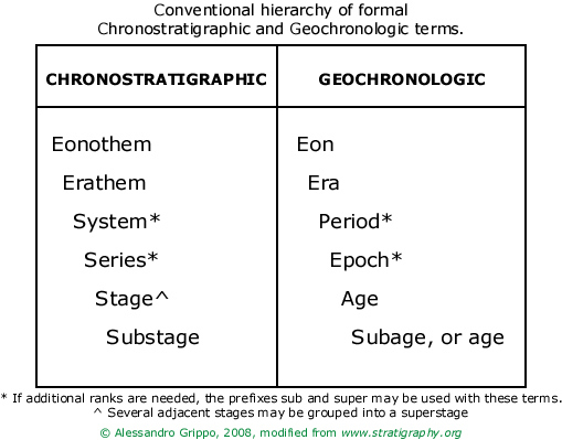
In chronostratigraphy, rocks are used as "the ancient book" of the previous example: they are, as a matter of fact, the only evidence for a specific time interval. Rocks deposited, for instance, during the Paleozoic are called Paleozoic rocks, as the book was called a Middle Ages book. These Paleozoic rocks are the tangible, visible, researchable evidence of events that happened during the Paleozoic time, and as such constitute a chronostratigraphic unit. While we do not know the exact timing of the Paleozoic rocks, we know that they were deposited after the Precambrian rocks, and before the Mesozoic ones. Chronostratigraphy is the element of stratigraphy that deals with the relative time relations and with the ages of rock bodies. A chronostratigraphic classification is the organization of rocks into units on the basis of their age or time of origin. The purpose of chronostratigraphic classification is to systematically organize the rocks forming the Earth's crust into named units (chronostratigraphic units) corresponding to intervals of geologic time (geochronologic units) to serve as a basis for time-correlation and a reference system for recording events of geologic history. A chronostratigraphic unit is a body of rocks that includes all rocks formed during a specific interval of geologic time, and only those rocks formed during that time span. Chronostratigraphic units are bounded by synchronous horizons. A synchronous horizon is a horizon, or surface that originated at the same time in all its parts. The rank and relative magnitude of the units in the chronostratigraphic hierarchy are related to the length of the time interval that their rocks subtend, rather than of their actual physical thickness. A chronostratigraphic horizon, or Chronohorizon is a stratigraphic surface or interface that is synchronous, everywhere of the same age. Such horizons can be used as the boundaries of a chronostratigraphic unit. | hierarchy of geochronologic and chronostratigraphic units | Last Updated • March 31, 2015 | The illustration below shows the conventional generic names used for, respectively, time-rock units and time units: Systems and Periods can be part of higher rank units but they themselves also include smaller rank units. For instance, an Erathem (like the Mesozoic) would contain several Systems (Triassic, Jurassic, Cretaceous); a System would contain several Series or Stages (the Cretaceous System would contain for instance, the Aptian and the Albian Stages). The same concept can be applied to time (chronostratigraphic) units: the Mesozoic era contains the Triassic, Jurassic, and Cretaceous Periods, and so on.
 www.stratigraphy.org is the official website of the International Commission on Stratigraphy | the geologic time scale | Last Updated • March 31, 2015 |
The following figure shows the Geologic Time Scale and the conventional names used for the different units, down to the Epoch/Series rank. Stages and Ages are excluded to avoid complications at this point but an example from the Cretaceous Period is provided in another image (see "Ages and Stages") below.
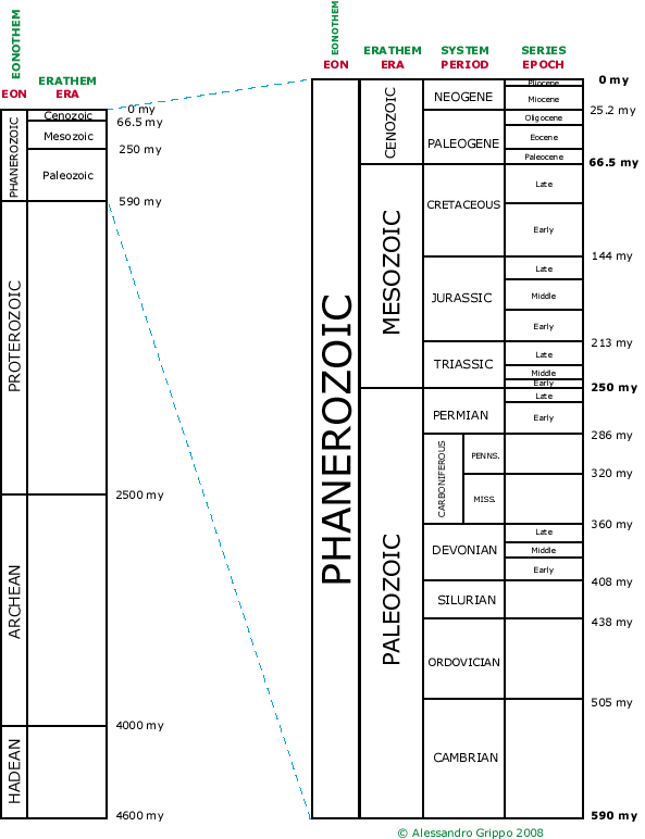
The Geologic Time Scale, compiled from Harland et al. (1982) and Haq et al. (1987). In red: geochronologic units. * In green: chronostratigraphic units. Notice that we can speak of, say, both Cambrian time and Cambrian rocks.
Cambrian time, or the Cambrian, is a time unit.
Cambrian rocks are simply those rocks that were deposited during the Cambrian Period.
The position within a geochronologic unit is expressed by temporal adjectives such as early, middle, late, etc., as in "Early Cambrian", as you would say early Saturday, or during Late April. We would then refer to upper Cambrian rocks, rocks that were deposited during the Late Cambrian. These are in fact rocks found in the upper part of the Cambrian system exactly because they were deposited during the last part (late time interval) of the Cambrian. | ages and stages
| Last Updated • March 31, 2015 |
A stage (and its time equivalent, the age) is a small-rank chronostratigraphic unit (geochronologic unit). In the following figure is an example of stages (and ages) relative to the Cretaceous System (Period):
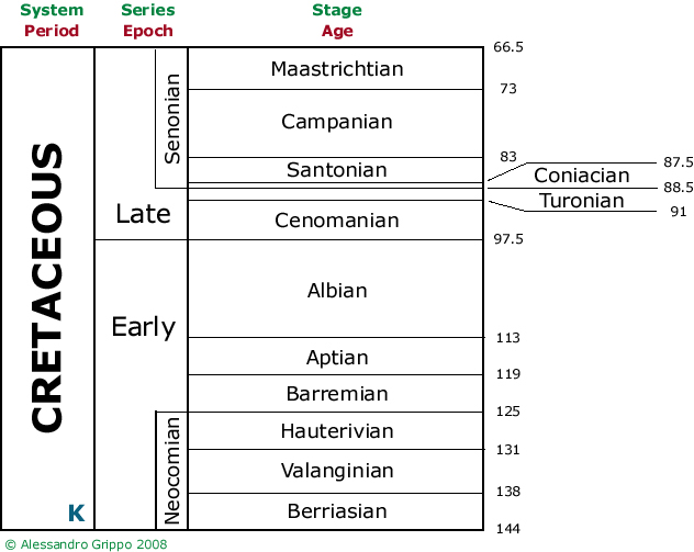
In red: geochronologic units. * In green: chronostratigraphic units. The stage has been called the basic working unit of chronostratigraphy, because it is suited in scope and rank to the practical needs and purposes of intraregional chronostratigraphic classification and correlation. In other words, it has a time dimension that can be applied to outcrops within the same region. A stage includes all of the rocks formed during the age with the same name. A stage is normally the lowest ranking unit in the chronostratigraphic hierarchy that can be recognized on a global scale. It is a subdivision of a series. A stage is defined by its boundary stratotypes, sections that contain a designated point in a stratigraphic sequence of essentially continuous deposition, preferably marine, chosen for its correlation potential. An example of a stratotype is the Mississippian/Pennsylvanian boundary in Nevada that was the theme and object of an SMC Geology 35 field trip during the fall of 2010. The selection of the boundaries of the stages of the Standard Global Chronostratigraphic Scale deserves particular emphasis because such boundaries serve to define not only the stages themselves but also chronostratigraphic units of higher rank, such as series and systems. The lower and upper boundary stratotypes of a stage represent specific moments in geologic time, and the time interval between them is the time span of the stage. Currently recognized stages vary in time span, but most range between 2 and 10 million years. The thickness of the strata in a stage and its duration in time are independent variables of widely varying magnitudes. That is, there is no relation between the thickness of a stage and its duration in time. The name of a stage should be derived from a geographic feature in the vicinity of its stratotype or type area. In English, the adjectival form of the geographic term is used with an ending in "ian" or "an". The age takes the same name as the corresponding stage. A substage is a subdivision of a stage whose equivalent geochronologic term is subage. Adjacent stages may be grouped into a superstage. Names of substages and superstages follow the same rules as those of stages. Most of this information comes from the International Commission on Stratigraphy website. The International Commission on Stratigraphy (ICS) is the largest scientific body within the International Union of Geological Sciences (IUGS). It is also the only organization concerned with stratigraphy on a global scale. One of its major objectives is the establishment of a standard, globally applicable stratigraphic scale, which it seeks to achieve through the co-ordinated contributions of a network of Subcommissions and Working Groups with a specific, limited mandate. The ICS and its expert stratigraphers promote and coordinate long-term international cooperation. Go to the Notes Page | Go to the Home Page | |||||||||||||||||||||