At the beginning of the semester we discussed the interior of our planet, identifying three concentric spheres:
the crust (either continental or oceanic), the mantle, and the core.
These three spheres differ in density, which is determined
by the study of body (P, or primary and S, or secondary) seismic waves reflection and refraction patterns.
S waves in particular do not propagate through liquids,
and it was observed that they bounce back (reflect) at the boundary between the core and the mantle.
While other data exist to support a solid inner core, this kind of behavior implies that the outer core is liquid.
Based on both the density of the core materials and comparisons with extraterrestrial bodies,
the composition of the core is estimated to be about 80% iron (Fe) along with nickel (Ni).
Fe and Ni, like many other metals, are characterized by metallic bonding,
that is, a bond where electrons are mobile, or "free" to move.
When electrons are set in motion an electrical current is generated
(for instance, when you turn on an appliance in your home), and a magnetic field is also produced.
On a hypothetical non-rotating Earth the liquid outer core would be still
and its "free" electrons would be only moving randomly at a subatomic level,
thus canceling each other's actions and generating no electrical current.
The only motion would consist in convection caused by differences in density, like in the asthenosphere.
On a rotating Earth instead, the liquid core is in motion and the electrons move within the core itself.
Motion because of convection and rotation generates an electrical current, that produces in turn Earth's magnetic field .
Why is this important to us as geologists and stratigraphers?
From one point of view, Earth's magnetic field influences the way certain rocks crystallize or deposit.
This can give us information about the processes that are related to both the magnetic field and the formation of the rocks.
From another point of view, the magnetic field affects the planet as a whole,
and its changes and variations occur at the same time.
These two facts open up incredible possibilities in terms of correlation:
imagine a change that affects rocks throughot the whole world and occurring in a very small time interval.
It is a physical equivalent of the concept of index fossil.
We will see in the next pages how this will become extremely useful for stratigraphy studies.
For now, let's proceed with order and try to understand the main concepts about Earth's magnetic field.
For further details read D. Gubbins, 2008. Geomagnetic Reversals, in Nature, vol. 452, p. 165-167.
| |
| earth's magnetic field | Last Updated • April 16, 2013 | |
Earth has had a magnetic field for a very long time.
We know that because we have found rocks as old as 3 billion years that are magnetized,
that is, that bear a trace of the influence of the magnetic field of the time during which they formed.
The magnetic field is continually maintained by a dynamo acting in the outer core.
This dynamo works in the same way of a car alternator.
Earth's rotation affects how the liquid outer core material moves
but the motion is actually originated by differences in density within the core itself.
The core is slowly solidifying from the center outwards,
and the lighter materials in it separate and rise, partially driving convection.
Earth's magnetic field resembles the magnetic field of a bar magnet
placed at earth's center and roughly parallel to Earth's axis.
The points where this hypothetical bar magnet intersects Earth's surface are called the magnetic poles.
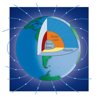
The image above shows the lines of Earth's magnetic field.
(from D. Gubbins, 2008. Geomagnetic Reversals, in Nature, vol. 452, p. 165-167).
At present, the north magnetic pole (NMP) is in the Canadian Arctic Ocean,
while the south magnetic pole (SMP) is in the Southern Ocean, south of Australia, just offshore the coast of Antarctica.
This map shows the position of the geographic north pole (at the center of the image)
and the projected trajectory of the north magnetic pole (pink line)
from 2001 (offshore Ellesmere Island, Canada) to 2050 (Severnaya Zemlya, or Northern Land, in Russia).
(Image from the Canadian Geological Survey web page)
As you can see from the figure above, on a short time scale, the NMP and its opposite, the SMP,
move yearly around the North Geographic Pole (NP) and the South Geographic Pole (SP).
Since the needle of a compass would point to the NMP, and the NMP is in general around the NP,
we can statistically say the our needle points north.
That is, even if the NMP moves continuously, it remains in the northern polar area.
Still, we have evidence from the past, that the NMP and the SMP switched places!
That is, if we could go back in time and use a compass, the needle would point south instead of north.
These are called magnetic reversals
and are at the base of magnetic stratigraphy as we will see later.
The use of magnetic prioperties in Plate Tectonics
Magnetic properties are also used in plate tectonics.
While this use is not properly part of magnetic stratigraphic, let's say a few words about it.
The magnetic field has, in any instant, a declination, an inclination, and an intensity.
The declination is the angle between the true north (that is, the NP) and the magnetic North (NMP).
because the NP and the NMP do not match, this angle changes in different locations:
for instance, in California has a value of -16°, while in central Europe it has a value of 2°.
As a consequence, we need to consider this angle when using a compass,
and every rock that records the magnetic field would be influenced by the declination value.
The inclination is the angle between the lines of the magnetic field and the horizontal surface.
It changes with latitude (0° at the magnetic equator, -90° at the SMP, +90° at the NMP).
It is recorded in rocks. So if you find a rock at the North Pole today which has a recorded 0° as inclination,
we can safely say that it formed at the equator, and it moved there as part of a plate motion.
In this way, we can easily reconstruct the paleogeography of a plate.
The intensity of the magnetic field is simply a measure of how strong the field is in a rock.
It is discussed in the next paragraph
| |
| how is earth's magnetic field recorded in rocks? | Last Updated • April 16, 2013 | |
We said earlier (discussion on plate tectonics) that once certain kinds of rocks are magnetized
they can retain the direction of the magnetic field acquired at the time of their formation.
But how do these rocks retain magnetization? What kind of rocks can actually show magnetization?
The best records are preserved in extrusive igneous rocks
but it is possible to observe magnetization also in sedimentary rocks.
Most rocks contain minerals that are naturally magnetic,
such as the iron oxides magnetite (Fe3O4) and hematite (Fe2O3).
When magma cools, these minerals become oriented in the direction of the magnetic field of the time,
or they are said to lock a permanent magnetic remanence.
A PERMANENT MAGNETIC REMANENCE forms in igneous rocks when, during the process of solidification of magma,
their temperature decreases below a certain threshold value called the Curie point.
The Curie point temperature is different for each mineral
(for instance, it is about 650°C for hematite and 578°C for magnetite)
but it is always below the solidification point of the mineral:
that is, after the mineral has turned into a solid (below the solidification temperature)
its magnetization is still not locked in.
It will be locked in once the temperature reaches the Curie point.
Once a magnetic mineral cools below the Curie point,
its magnetization is locked permanently into the crystal,
which is at this point aligned in the direction of Earth's magnetic field of that specific time and place.
This kind of magnetization is called thermal remanent magnetization (TRM)
and it is very important in basaltic lavas, which contain a lot of iron and form very quickly
(this means that our record of the magnetic field is specifically related to a very short time interval).
There are other ways to lock magnetization in rocks:
for instance, once a rock is weathered and eroded, its magnetic minerals,
as any other part of a rock, may become sedimentary particles.
These particles, or grains, behave like small bar magnets,
and when they settle they can become aligned in the direction of the magnetic field of the time.
This is called detrital remanent magnetization (DRM),
and it is up to three times less strong than TRM.
A similar concept applies if weathered iron is re-precipitated somewhere else:
for instance, remember that hematite can also act as a cement in clastic sedimentary rocks,
or that it can be moved around during metamorphic processes.
In both these cases, the newly crystallized hematite will acquire a new magnetization,
called chemical remanent magnetization (CRM), relative to the time of crystallization.
Notice that with CRM the acquired magnetization is not that of the rock
but rather that of the crystals that form within the rock (the cement).
So, despite the fact that we can have three different kinds of permanent magentic remanence
(thermal, detrital, and chemical), from a magnetic point of view the best rocks are extrusive igneous rocks
(intrusive igneous rocks cool so slowly that the magnetic field itself can sometimes change during the process of solidification).
Remember that igneous rocks can also be dated numerically, through radioactive methods.
It becomes then possible not only to measure all the parameters of the magnetic field in a rock (what happened and how)
but also tell when these parameters where locked in the rock (when it happened).
| |
| Magnetic Field Reversals | Last Updated • April 16, 2013 | |
Extrusive igneous rocks are found in the oceanic crust and at several other locations on Earth,
including for instance the Hawaiian islands or the Columbia Plateau of eastern Washington and Oregon.
By far, the most common of these extrusive igneous rocks is basalt,
which is formed by minerals (such as amphiboles and pyroxene) that contain a high amount of Fe.
These iron-rich minerals become magnetized at the moment of magma solidification.
and the newly acquired magnetization will be that of the moment of crystallization.
This implies that we are able to tell how strong the magnetic field was, and what was its direction at a certain time in the past
because basalt is an extrusive igneous rock that can be radiometrically dated.

The Amboy Crater: a volcanic crater made of basalt in California's Mojave Desert (San Bernardino county)
Oceanic crust in particular forms at mid-ocean ridges, where two plates move apart from each other.
The new oceanic crust forms linear segments of basalt, parallel to the mid-ocean ridge structure itself.
The age of the oceanic crust increases (symmetrically) moving away from the ridge itself, in both directions.
When you measure the intensity of the magnetic field, at any location, you would have a result that comes
from the combination of the general Earth's field of today and any local field generated by magnetic rocks, if present.
When geologists and geophysicists measured the intensity of the magnetic field across the mid-ocean ridges
in different parts of the world, they always found a symmetrical pattern for it too:
those parallel strips of basaltic oceanic crust that presented the same age
(and were thus at the same distance from the ridge but on opposite sides of it)
also presented the same kind of magnetization (intensity and direction).
The magnetic field measured at the ocean bottom was not uniform as expected, but presented some anomalies:
the intensity of the magnetization was never equal to that measured on land,
it was either weaker or stronger than the normal Earth's magnetic field.
Also, these anomalies were symmetrical, the axis of symmetry being the mid-ocean ridge.
While this puzzled geologists at first, it can now be easily explained when we think that
the actual magnetization of the basalts of the oceanic crust either subtracts or adds
its intensity to that of today's Earth field.
So the anomalies recorded by geologists aboard oceanographic vessels
were the result of the addition of today's Earth magnetic field intensity
with the magnetization recorded in the basalts of the oceanic crust at the time of their solidification.
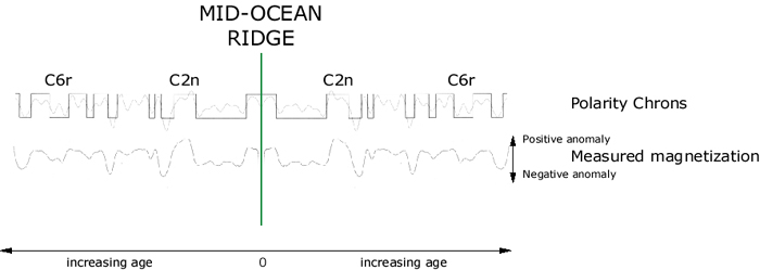
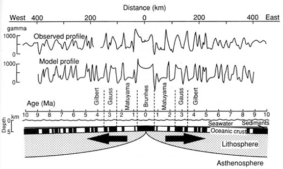
This illustration is an imaginary profile (built from a real sample
taken offshore the coast of Japan) that shows magnetization across a mid-ocean ridge.
The ridge is represented by the vertical green line.
The "normal" magnetic field would be a horizontal line, but what we see is
an up and down pattern that is specular across the ridge itself.
The stunning revelation was then that the Earth's magnetic field in the past was not always like today's:
when it was opposite to today's, its intensity, now recorded in old basalts,
would subtract from our present day field (a negative anomaly);
when it was like today's, its intensity would add to our present day field (a positive anomaly).
So there were time intervals during which Earth's magnetic field was opposite to what we observe today,
and this was true for the whole planet, and at the same time.
It sounds like something we can use for correlation and dating!
Today's Earth magnetization is defined as "normal", and its opposite "reversed".
The time during which the field remains consistent is called a chron.
A chron is a magnetostratigraphic unit.
We called "normal chrons" the time intervals of the past during which magnetization was the same of today
and "reversed chrons" those during whcih magnetization was the opposite of today.
Today we are living in the first normal interval, or Chron 1 normal (C1n).
Going back in time, we wil have a C1r, C2n, C2r, C3n and so on.
C2n and C6r are shown as examples in the image above.
These concepts will be reinforced in the next paragraph.
It then became apparent that Earth's north and south magnetic poles had flipped,
or switched positions several times in the past:
these switches are recorded in the oceanic crust at the bottom of the ocean.
We can see how, as the crust forms, it becomes magnetized by the magnetic field,
leaving linear segments of new crust on each side of the ridge.
When the magnetic field reverses, the new strip of crust is formed with a magnetization in the opposite direction.
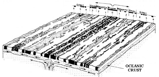
This image shows how different magnetic polarities can be represented in the basalts of the oceanic crust.
We can not of course actually SEE the strips, but we can record them with geophysical instruments.
When we represent them visually, it is conventional to use black for normal magnetic field
(today's and any other time in which we had the same orientation) and white for reversed magnetic field.
figure: modified from Vine, 1966 - Spreading of the Ocean Floor: New Evidence. Science, 154, 1405-1415
There is no particular reason why the magnetic field reverses:
the field itself is not constant and can oscillate between extremes
and it is a matter of chance whether a decrease in the field ends up
with it regrowing with the same or rather with the opposite polarity (that is, a flip).
During a reversal, the magnetic pole weakens, typically for several thousand years.
The direction then changes, relatively quickly, and then the reversed field
grows in strength over another few thousand years.
Recently, reversals occurred on average every 300,000 years.
The last reversal though was 780,000 years ago, so we are somehow late on this pattern.
In this interval of time, the magnetic field started to change at least ten times
but it always went back to its current polarity: we call this an excursion, or aborted reversal.
| |
| magnetic stratigraphy | Last Updated • November 5, 2013 | |
During Earth's history, the magnetic field reversed with no particular frequency or pattern.
There have been intervals when there were no reversals at all,
for instance during the Cretaceous.
Sequences of magnetized rocks from the ocean bottom that can be dated numerically
with radioactive methods
have revealed the history of these reversals during the Cenozoic and much of the Mesozoic.
Remember that oceanic crust is lost in subduction and that there is no oceanic crust older than the Late Jurassic.
As a consequence, our record for times older than the Late Jurassic
can only come from scattered igneous and sedimentary sequences from the continental crust.
Again, keep in mind that magnetic field reversals occur simultaneously, at the same time all over the world.
This simultaneity allows scientists to perform very accurate correlations.
This image shows the formation of marine magnetic anomalies at an ocean ridge undergoing seafloor spreading.
figure: modified from Pitman and Heirtzler, 1966. Science, 154, 1164-1171
The periods when the magnetic polarity was the same as it is today are known as normal intervals,
while the periods when polarity was the opposite of what it is today are called reversed intervals.
Each period with either a normal or a reversed polarity is called a chron.
(Sometimes smaller, neighboring periods are part of the same chron).
A chron is a magnetic polarity time-rock (stratigraphic) unit.
Why is a chron a time-rock unit?
Because it defines time based on the physical presence of rocks
with a specific character (either normal or reversed magnetization).
Or, you get to see and touch a rock, and in this case you know for sure that the rock
represents a time interval during which you had either a normal or reversed polarity.
With lithostratigraphic units, you can never assume that!
A magnetic chron is usually assigned a number (starting from the present)
and either a letter N for normal or R for reversed.
For instance, the 20th normal interval starting from the present will be indicated as Chron C20n
(see also the previous figures)
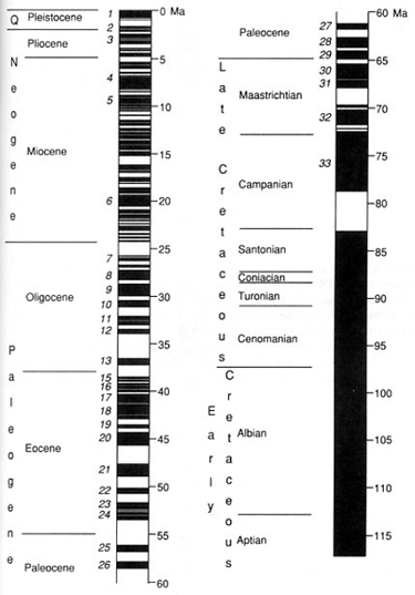
This image shows the Geomagnetic Polarity Time Scale of Cox (1982), from 0 to 118 Ma.
figure: modified from Cox, 1982, in Butler, 1992
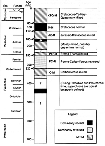
This image shows the Polarity Superchrons during the Proterozoic and Phanerozoic.
figure: modified from Cox, 1982, in Butler, 1992
Magnetic stratigraphy generally provides for more accurate correlation than biostratigraphy.
The problem we might have with magnetostratigraphy is this:
how are we able to assign a certain sedimentary sequence to a particular polarity time-rock unit (a chron)?
We can easily tell what the magnetization of a sequence is,
but if we only have two kinds, normal and reversed, which normal and which reversed are we talking about?
A solution might come from studying the magnetic signature, or a distinctive sequence of reversals.
A signature would have a unique pattern that would allow its identification within the magnetic polarity scale.
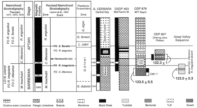
(from J. Channel et al., 1995. Late Jurassic-Early Cretaceous Time Scales and Oceanic Magnetic Anomaly Block Models, SEPM Special Publication 54)
This figure shows how the integration of magnetostratigraphy, biostratigraphy and geochronometry of three different areas
fits with the chronostratigraphic scale (Barremian and Aptian stages of the Lower Cretaceous)
Go to part 1 | Go to part 2 | Go to part 3 | Go to part 4 | Go to part 6 | Go to part 7
Go to the Images Page | Go to the Home Page
© Alessandro Grippo, 2009 - 2013
| | | | |